Prison Hill SOTA Activation

Although this image was a couple of days earlier than my SOTA activation, I am setup on Prison Hill with the KX1 radio and the AX1/AXE1 antenna for a noon-net check-in.

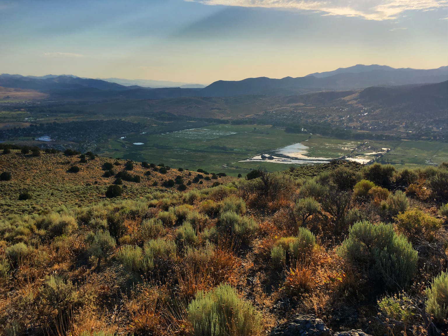
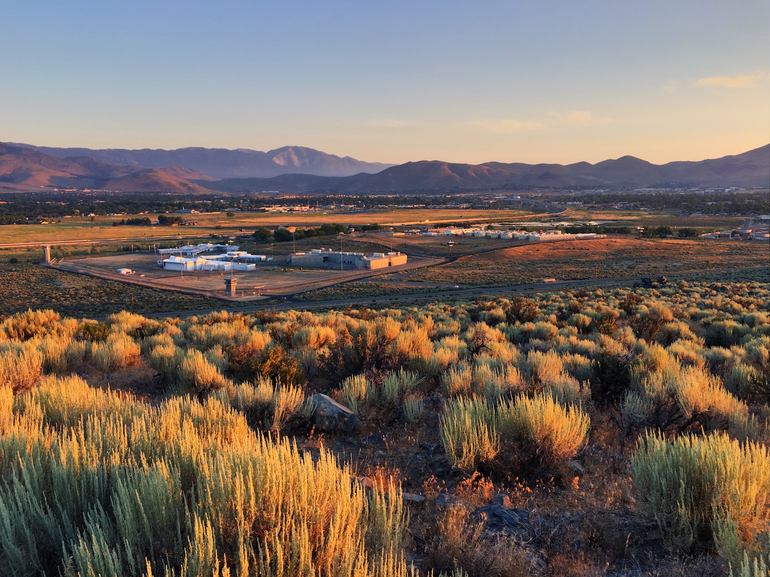
Last Saturday Older Son and I drove the 4Runner up to the Prison Hill summit to setup and activate Prison Hill for Summits on the Air. SOTA is a game played by amateur radio operators who operate from designated mountain/hill tops for chasers to contact and make a pre-defined exchange. Both activators and chasers receive points for the contacts.

But the real fun is getting outdoors, setting up for portable operations, and making a few contacts with other radio operators. I enjoy the activation part of the game and try to get a few activations in whenever I can.

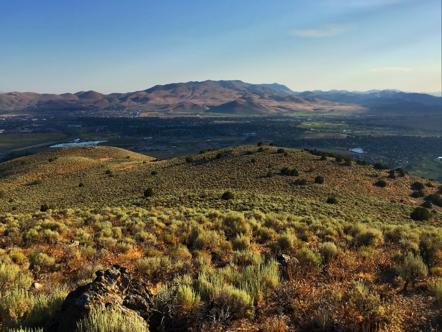
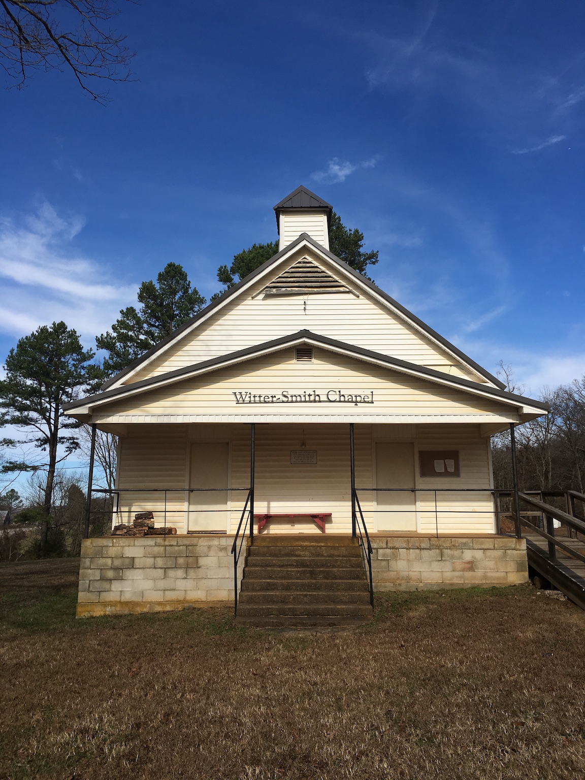
The image is one from our hike up Prison Hill (and helluva hike, by the way) where I setup the Elecraft KX1 radio and the Elecraft AX1/AXE1 antenna and checked in to the 40m noon net using Morse code. That was a good day. On Saturday, we setup my KX3 portable station a few tens of feet from this location and put up a proper wire antenna. I listened to the 40m band for awhile and picked out a couple of CW stations callsigns. But I was too chicken to respond. I am still learning Morse, so am not up-to-speed (literally) yet. But I can copy and send a basic exchange if the other operator is patient.

So I moved to the phone portion of the band, found a quiet frequency, and asked if it was in use three times. That is good operating policy. Hearing nothing, I started calling “CQ” and then spotted myself on the SOTAwatch website.

In just a few minutes I was working a pile-up. A pile-up occurs when there are multiple stations calling a running stations to make a contact. It is difficult to separate out the calls and get callsigns. So, one has to work a pile-up. This was my first time working a pile-up, but I have heard them worked plenty of times so I knew the basic procedure.

In less than half an hour I had almost a dozen contacts, including three summit-to-summit contacts, which are highly desirable. After a few more calls, I heard no more stations. I thought for a moment about switching bands to 20m and doing it again, but decided that I had achieved my objective and would tear down and go hike a bit and search for a geocache.

Older Son and I had one in mind. We hiked the few hundred yards to the site and searched for almost an hour before deciding that it was no longer there. The last log was four-years earlier. So we were not particularly surprised that the cache had gone missing.

The hike back up to the rig was strenuous, given it was a big climb. But that was good for me too and I don’t mind the exercise.

We put away our things and started back on the trail out when a good friend and amateur operator pulled up in his rig. So, we practiced social distancing and visited from our respective vehicles for an hour before calling it a day and heading back down the trail.

It was a really, really good day. I am so very thankful and grateful for it.

Mead Cafe

I am sitting in my (new-to-me) camper at the KOA Journey in Lyman, Wyoming this afternoon. I am heading home after a long roadtrip that took me to Lubbock, Texas, to Duran, Oklahoma, to Rolla, Missouri, to Denver, Colorado, and now the last leg back to Carson City.

I have been on the road for more than three weeks. All of my nights were spent in my camper, a 2017 Forest River Rockwood. It is an A-Frame that folds down and is compact in the down position. The 4Runner pulls is pretty will, slowing only on the steepest hills. I will write more about it later.

I am learning a lot about the camper lifestyle. There is a lot for me to learn about setting up my rig. It is interesting to think about a small house and how to make it work for me efficiently.

One thing I learned is that there are many campgrounds operated by county and municipal governments that are very inexpensive. I stayed at a number of municipal campgrounds where I had both electricity and water for about ten bucks a night. That is a bargain compared to what I was paying for lodging.

But I am getting ahead of myself. I want to write about an interaction I had with Marylinn and Anna, who work the floor at the Mead Cafe. The Mead Cafe is located between Durant and Lake Texoma. Older Son and I stayed at one of the Corps of Engineers campgrounds at the lake. That was an interesting experience in and of itself that bears some additional writing, too.

We met Young Son and his girl at the Mead Cafe on a Saturday morning for breakfast. I was sufficiently impressed that it became our go-to breakfast place during our stay there.

On our last morning in Oklahoma, Older Son and I stopped in for breakfast. It was a quiet morning and both women working the floor stopped to chat several times while Older Son and I drank coffee and prepared for our day.

The younger, Anna, told us about the dog she lost to an automobile and the new dog she had taken in. She asked many questions about The Girl and her service work. It was my pleasure to listen to her story, share her grief for her lost companion, and share her joy with her new companion.

The older, Marylinn, told me stories about “service dogs” — one in particular about a dog whose handler put her plate on the floor for the dog. (Yes, that caused even my eyebrows to rise!) She asked many questions about The Girl, as well. She told me that she would not have known The Girl was there but for Anna telling her there was a dog under our table.

The Girl is the real deal. She is not perfect, but neither am I. We are a good team. She knows her job and she knows me, sometimes better than I know myself. She knows what I will do before I do and anticipates our comings and goings. She knows to stay out of sight when working and she knows to play like all hell is loose when we play.

Again this morning, while I had breakfast at the Cowboy Cafe near my campsite, one of the young women working the floor came by. She told me “If I had not seen her come in, I would not have known there was a dog in here.” The Girl looked at her from the top of her eyes, staying on the flood near my feet like she always does.

After breakfast, The Girl and I drove to the Lyman Cemetery. I figured there would be a geocache there and we both needed some outside time. While I was searching for the geocache, The Girl got all rowdy, running around me on the grass like a crazy dog.

I paused my search, crouched, and said “I’m gonna get you…” and we had a great chase there on the grass. Finally, exhausted, she laid on the grass, panting and enjoying the coolness of the green.

I found my geocache, signed the log, and we headed off to Fort Bridger to walk the site and enjoy some of the history of the area.

Yes, she knows how to work and how to play. She is a good teacher for me and the best companion I could ask for.

MOLLE Generation 2 Three-Day Assault Pack

This is my MOLLE Generation II 3-Day Assault Pack.

About a year ago, I bought a surplus MOLLE Generation 2 3-Day Assault Pack. I wanted a pack to use as a day-pack so I could carry some water, a few emergency supplies, a camera, and repair materials for geocaching. I have come to love day hikes. I love geocaching in more remote areas — those that are more difficult that park-n-grabs.

I did some reading before selecting a surplus pack. I did not want to spend a lot of money, at least not initially. I know that military packs are developed to meet specific requirements, but I also know that materials are top-notch as required to stand up to the rigors of combat use.

From many perspectives, this is a great pack. There’s lots of room in the main compartment and a separator to keep the plastic stiffener apart from the contents of the main compartment. The main compartment is zipper closure (with a weather flap) and the zippers are high quality. You can put a lot of stuff in the main compartment. I keep a 3-liter Camelbak in there as well as a cover if I start out cool or think it might turn cool. There is much room left over.

There are two additional pockets on the front of the pack, a large compartment with zipper closure (and weather flap) that could hold food or necessaries that are too large for the smaller front pocket. I can put a couple of bushcrafting books in there and have room for some additional things.

The smaller front pocket is velcro closure (good velcro too) and has room for all of my geocaching tools, replacement logs, and plastic bags. I could keep a decent size pocket notebook in there as well.

The straps are thin but wide. I would say they could be good for loads up to 20 pounds or more, depending on your tolerance for discomfort. I get tired of the straps after five miles with a 20-pound load.

This is where the shoulder strap for the MOLLE Generation 2 Assault Pack attaches to the pack.
I’ve learned a lot using this pack over the last year. I carry my load a little high. I don’t like the load hitting me in the ass. So the straps are fairly tight and the bottom of the pack sits in my lumbar regions, just above my hips. Because of that, the insertion points for the end of the straps poke me in the back. For short hikes this is just annoying and I can ignore it. For anything five miles or more, it’s uncomfortable. I suspect that if I was wearing the FLC and plates, that the straps would not dig my shoulders or poke me in the back.

I’d also like a separate pocket for my Camelbak. I know they are tough, but I’d like my water separate from my other gear.

The MOLLE is wonderful! There are tons of pockets that can be added to MOLLE-equipped gear. I like have cubbyholes to put things instead of a dump into the main pocket. So, my replacement pack will have MOLLE and I will use surplus MOLLE pouches to add pockets to my new pack.

There are many things about the MOLLE Assault Pack I like. But I need a pack that is comfortable to wear with the loads I carry. This one is not going to work for me.

Say “Hello” To My Little Friend

While hiking and geocaching one Saturday, the Girl and I came across this little guy. No, it isn't a pit viper so she didn't react to it until she saw it.
While hiking and geocaching one Saturday, the Girl and I came across this little guy. No, it isn’t a pit viper so she didn’t react to it until she saw it.

Last Saturday the Girl and I rose quite early to hit the trail up the Prison Hill ridge. I had identified a handful of geocaches I wanted to find and I wanted a good long hike with some relief to challenge my legs. So, I loaded up the geoRig with the Girl, water, and my pack and we headed east out Fifth Street past the roundabout.

One used to be able to drive on the trails in this area. But, things changed in the last year. Motorized vehicles are no longer permitted on the trails. (What do I think about that? I suppose it doesn’t matter, does it?) So, we parked the rig, got out, loaded up (or I loaded up), and started up the hill.

The climb up wasn’t so bad at first, but the trail steepened as we went along. With full-time all-paw-drive, the Girl didn’t have an issue with the trail. But her old man could feel the load and the steepness a bit. Still, it felt really good to be out there and I loved the challenge.

The view of Carson City from the Prison Hill ridge was fabulous, especially this early in the morning.
Once near the top, the slope lessened and the hump became a hike. We puttered around, enjoying the view. The view was wonderful with the rising sun slanting across the city and surrounding mountains.

We worked our way along the trails, finding our geocaches (or at least I was finding geocaches; she was finding lizards). I had to refer to Google Maps a couple of times to make sure I had the right trail. (Lesson learned — make routes along the trails and upload those to my GPSr before heading out.) There was so much to see and experience. The cool morning was perfect. There was just enough breeze to cool my sweating body. The crunch of sand and gravel under my feet was punctuated with the occasional pop of a larger rock being kicked from the path or rolling under my boots.

When we crossed the ridge to the east side I began to feel the sun. The breeze was blocked by the ridge and the sun was already warming. Fortunately, I had plenty of water. The Girl didn’t seem bothered by the sun and was intent on hunting lizards, or her preferred prey, squirrels!

“Squirrel!!!!!” she seemed to shout and would go bounding off over the rocks in pursuit. Or course, the “squirrel” might be a rabbit, but no matter… the chase was on.

One of her characteristics is that no matter which way I’m going, she’s out in front about 20 yards. If I turn and go in a different direction, she will run past me, usually blasting me with coarse sand. So I laugh at her. (And I sometimes change directions on purpose just to mess with her.)

The morning light on the Carson River floodplain reflected from the flood irrigation of the working fields.
As we neared the point where we would turn back on the north connecting loop of the trail system we were walking, I noticed something on the path. There was a small snake, sunning.

What a beautiful creature! It was not aggressive and was clearly digesting a large meal, probably one of the many lizards we see on every outing. I squatted there on the path, looking at the animal.

The Girl, always curious about what I’m doing, came trotting back up the path. She seemed to be saying “Watcha doin’, Man?” As she approached, she (being the ditz she is), didn’t notice the snake and stepped on it.

Of course, that got a reaction from the sluggish animal! It vibrated its tail, feigning the dangers of a rattlesnake, coiled a little, and struck at my walking stick.

The ditz, of course, didn’t notice until she saw it move. Then she saw how it moved and I watched her body language change from curiosity to “Oh Shit! Those hurt us!” and she stepped quickly away from the now-pissed-off snake.

That was good to see. It means her rattlesnake aversion training has taken. The animal didn’t smell like a pit viper or I’m sure she would have alerted sooner. I was pleased.

Nonplussed, I prodded the animal a bit more so I could get a picture with my iPhone. I should have retrieved my compact camera from my pack, but my iPhone was in-hand.

After my picture, I shooed the snake off the path so it wouldn’t be stepped on (again), rose, and moved on. It wasn’t much farther until we rejoined the split where we had gone to the west side of the ridge and worked our way back down the steep part to the flat near the rig.

We hiked a bit more than five miles that day. We made it back to the rig by 0900 or so. The Girl was plenty tired and wanted her water at recline. So, I put her bowl between her front paws as she rested in the shade of our rig. She drank a couple of bowls of water while I put away my gear. Then we mounted up and went off for me to get breakfast.

Of course, I held back a couple slices of my bacon to sweeten her kibbles when we returned to our room. She really likes her special sauce.

What a great day!

Carson City from Prison Hill

The Girl and I rolled out (real) early Saturday for a long hike and some geocaching. We parked the rig at the north end of the Prison Hill Range and humped it up the trails from the parking area. Near the top we were greeted with Father Sun and this staggering view of Carson City.

Saturday morning, the Girl and I rose really early to get a headstart on the day. I wanted to hike the northern part of the Prison Hill range, get some good exercise, and find a few geocaches. We were at the parking area before sunrise. (N.B. One used to be able to drive some of these trails — a year ago — but now the area is fenced off.) I donned my pack, initialized the GPSr, and we were off.

We humped it up the north end of the hills and were greeted with a wonderful view and wonderful light. I stopped for a few minutes to make a few captures. Then we were off again.

The initial climb was moderately challenging. But once up on the high ground, the trails were not bad at all. We hiked about halfway down the range before turning east to get the trail on the east slope and find a couple more geocaches.

By the time we got back to the rig, we were both done. I was ready for food, coffee, and a break. The Girl laid in the shade by the rig and waited for me to provide water. She settled with paws on both sides of her bowl, reclining while she drank her water. Then she was up in the rig and we were off to Grandma Hattie’s for breakfast.

It was a great morning. I’m stiff, which is also good. We also found a few geocaches to add to my list. Saturday was a good day.

Little Wildhorse Canyon

The Girl and I hike partway up Little Wildhorse Canyon. it was my first slot canyon and I hope it will not be the last.

A few days ago, the Girl and I hiked up Little Wildhorse Canyon. We didn’t go quite all the way, but far enough to get the geocache up there and to get a taste of hiking slot canyons. Both are addictive, I think.

There were a couple of spots where the Girl needed a hand. Mostly she’s independent, but this was a five foot jump and I don’t think she can do that without hurting herself. So, I lifted her up until she got purchase and she was off and running, literally.

On the way down we had a navigate the spot again, but this time I found a way she could do herself. Just like a two-year old, “she’d rather do it herself.”

By the time we got back to the car, she was done. It’s not often she’s trailing behind me. This time I ran away from her.

Green River, Utah

While geocaching on Tuesday afternoon, the Girl and I hiked up Black Dragon Canyon to the petroglyph site (and geocache). It was a great hike and the views were stupefying.

The Girl and I started early Tuesday morning with a long walk about the circuit I chose that takes us along the railroad tracks, the golf course, and back down Main Street to the hotel. We were up and walking before most folks were out and about. It isn’t that there are that many folks here out and about. Green River is pretty quiet.

We bought a bite of breakfast and then stopped at the park for a few minutes for me to spend some time in my journal and think about the day. Then we drove out to see the new diversion dam that was recently updated to keep the irrigation canals operational. As part of the upgrades, fish and boat passages were added to the structure. However, the river is high enough that there wasn’t very much to see.

We visited the Powell Museum and watched the movie of Powell’s exploration of the Green River and Colorado River. The movie was excellent and worth the price of entry into the museum. The Girl didn’t like the thunderstorm sequences much, but settled back down when the thunder ceased.

After a bite of lunch, we drove over to public library where there I could get a desk and Internet connection. It’s a nice little library and seemed to be busy enough. I chose a few geocaches and loaded my GPSr for an afternoon run.

After waffling a little about the heat, the Girl and I headed west to the San Rafael Uplift area. I’ve driven through it a dozen times or more, but never gotten off the road to explore. The geocaches on my list took us to some fine sights and I’m glad I made that trip.

The afternoon brought some thundershowers and some cooler air. I’m fine at 90F outdoors so long as I have water. The breeze and break in the bright sun made the afternoon excursion much more fun.

I came away with a few captures that I really like. One of them is attached.

Rifle Falls

The Girl and I went out exploring yesterday and really enjoyed the stop at Rifle Falls.

The trip yesterday to Rifle Falls was well worth the stay in Rifle, Colorado. The Girl and I had a blast exploring. We even found a few geocaches while we were out and about.

Witter-Smith Chapel

The Witter-Smith Chapel, adjacent to a geocache-hiding cemetery in rural Arkansas.

Traveling along State Highway 23, I stopped out in the middle of nowhere Arkansas at the Witter-Smith Chapel. The stop was partly for a break for me, partly for a break for the Girl, and partly to see if I could find a geocache that was listed near the adjacent cemetery.

I accomplished all tasks but one — I didn’t find the geocache. But the Girl and I had a nice break from the 4Runner, the road, and a good stretch of the legs. It is important to remember those who lived before us and I honor those folks when I visit their graves. As a boon, the chapel made a nice capture.

Version II, On the Geocaching Path

This is a second version of my capture made while geocaching in John C. Rudy County Park, York County, PA.

I really like this capture. I was disappointed with my previous version because the post-processing was limited by the application I used to correct the perspective of the original.

The iPhone (like all phone cameras) uses a lens with a fairly wide angle focal length (for the sensor size). My guess is that the perspective of the iPhone 6S camera is equivalent to about a 28mm lens (for the 35mm format). The thing about wide angle lenses is that they tend to make vertical objects appear to lean over (either backward or forward, depending on which direction the camera is tilted). In my capture, I tilted the camera back to bring in more of the trees and sky and to put the path near the bottom of the capture. Therefore, the trees appear to lean backward, although they don’t.

I have on older application (from my previous use of the iPhone) called Perspective Control. It’s a simple program to use and works well. My only gripe about the software is that it will only export an image with a size of 1,152 pixels on the long axis. That’s a loss of about three-quarters of the linear dimension of the camera output. That is not acceptable.

So, I found another application yesterday, SKRWT, that does the same thing as Perspective Control. I spent the three bucks for the software, then reworked the image. I adjusted the perspective using SKWRT, then post-processed the corrected image using Photogene4. I had to downsample the result slightly to work with my weblog, but the result is superior to my previous attempt.

I think this one is a keeper. The capture is not bad at all for a phone camera.